A Guide to Hiking the Heather-Maple Pass Loop in Washington
Overlooking the Cascades from Maple Pass
Distance:
7.2 miles round-trip
Elevation Gain:
2020 feet
Area:
Okanogan-Wenatchee National Forest
Pass:
NW Forest Pass
America the Beautiful
The Heather–Maple Pass Loop is a North Cascades classic—and for good reason. This 7.2-mile loop trail offers a little bit of everything: forested switchbacks, wildflower-filled meadows, alpine lakes, and jaw-dropping ridge views. Hike it clockwise for a steep but rewarding climb, or go counterclockwise for a gentler ascent. In fall, the golden larches light up the trail, making it one of Washington’s most photogenic hikes.
I have been hesitant to write a blog post about the Heather-Pass Loop trail but I have done this hike 3 times and there is absolutely no reason to gatekeep this. Plus, I’ve taken some of my favorite photos on this trail.
There are ways that we can continue to do our part to protect one of Washington’s most beautiful trails — brush up on the leave no trace principles and only hike on established trails.
Overview

Tex on top of a boulder on the Maple Pass Loop trail.
Located about 3.5 hours from Seattle along the scenic North Cascades Highway (Highway 20), the Heather–Maple Pass Loop is one of Washington’s most iconic hikes—and for good reason. This 7.2-mile loop offers everything from forested switchbacks and alpine meadows to dramatic ridgelines with panoramic views. With around 2,000 feet of elevation gain, it’s a moderately challenging hike that rewards you every step of the way.
Because of its popularity—and especially during “larch madness” in late September to early October—this trail can get very crowded, particularly on weekends. Arrive early or go midweek if you’re hoping for a quieter experience. Regardless of when you go, Heather–Maple Pass is the kind of trail that sticks with you long after you’ve left the mountains.
Always have a plan B when visiting this area — I have seen cars lined up on both sides of Highway 20 and it becomes dangerous. I recommend checking out Blue Lake, Cutthroat Pass, and Washington Pass Overlook while you are in the area.
Getting to the Trailhead

Washington Pass
Trailhead Coordinates: 48.5162, -120.7354
The trailhead is located along the North Cascades Highway (Highway 20) and I truly enjoy driving on it. The road can sometimes remain closed until mid-June. However, in recent years, the road has been opening earlier. You can check for the most up-to-date information for Highway 20 through WSDOT.
The Washington Pass Overlook is a good place to stop before or after hiking the Heather-Maple Pass Loop if you have time to spare. The trail to the overlook is mostly paved, making it accessible for most folks. There is hardly any elevation gain but you do have to climb up and down a tiny bit to get to the overlook.
I enjoy coming here after the hike because the sun is generally setting but it depends on what time you do the hike. I’ve always parked at this pullout to get the iconic shot of the North Cascades Highway (left).
Hiking the Heather-Maple Pass Loop
A lot of trip reports online recommends doing this hike counter-clockwise and I have only done it this way. The climb is more gradual but be mindful that the hike back to the parking lot is steep. It really depends how you’d like to tackle the hike but hiking the trail either way will still get you up to one of the finest viewpoints in Washington.

Is this trail dog friendly?

This is also when you will start to hug the North Cascades National Park boundary.
Upon taking a closer look at the map, it turns out that dogs are not allowed on the high ridgeline up to Maple Pass. This section of the trail crosses into North Cascades National Park, and national park rules apply—which means no dogs are permitted, even on leash. Interestingly, the trail appears to closely hug the boundary line between national park and national forest land, which can be confusing. I recommend double-checking with the Marblemount Ranger Station or the visitor center at Newhalem if you're unsure.
I’ll admit—I’ve made the mistake of taking my dog up to Maple Pass before, thinking the trail stayed entirely within national forest land. Don’t be like me! If you’re hiking with your furry friend, you can still enjoy the trail up to Heather Pass, which offers beautiful views and stays within dog-friendly boundaries. Just remember that dogs do have to be on leash at all times.
That said, most people hike this loop for the full Maple Pass panorama—so you’ll have to decide if it’s worth doing the partial hike or saving this one for a dog-free day.
Mile 0–1.2: Rainy Pass Trailhead to Lake Ann Junction

Lake Ann

The colors were starting to change in late September
The trail starts at the Rainy Pass Picnic area and takes you through a dense forest before you start to break out of the tree line and climb steadily towards Heather Pass. When you start hiking counterclockwise, you will encounter a sign to Lake Ann. I’ve never taken the hike down to Lake Ann so I’m not sure what the lake itself looks like.

A great spot to take a quick break - overlooking Lake Ann and the Cascade Mountains.
Mile 1.2–2.8: Steady Climb to Heather Pass
From the cutoff to Lake Ann, the trail continues and begins climbing more steeply through open meadows dotted with heather, wildflowers in summer, or golden larches in fall. Switchbacks carry you up to Heather Pass (~2.5 miles in), where the terrain opens dramatically and the views expand.
I always take a moment to stop here and capture how the cascade mountains pose as a dramatic backdrop to Lake Ann - which looks very small.
After this section, the elevation begins to ramp up so it is always nice to take a breather here and soak in the views.
Heather Pass is named after the alpine heather plants that grow abundantly in the subalpine meadows around the area. These low, mat-forming shrubs—usually white mountain heather and pink mountain heather—are common in the North Cascades.
Mile 2.8–4.1: Heather Pass to Maple Pass

August 2019

September 2024
This is when the trail begins to really show off its views. The climb can feel hard but don’t forget to look around, the trail leaves behind the forests and the heathers and climbs steadily up to the high point - Maple Pass. As mentioned, I have done this hike 3 times and every time I get to this section, the views are slightly different (see above photos for the contrasting vegetation during different seasons).
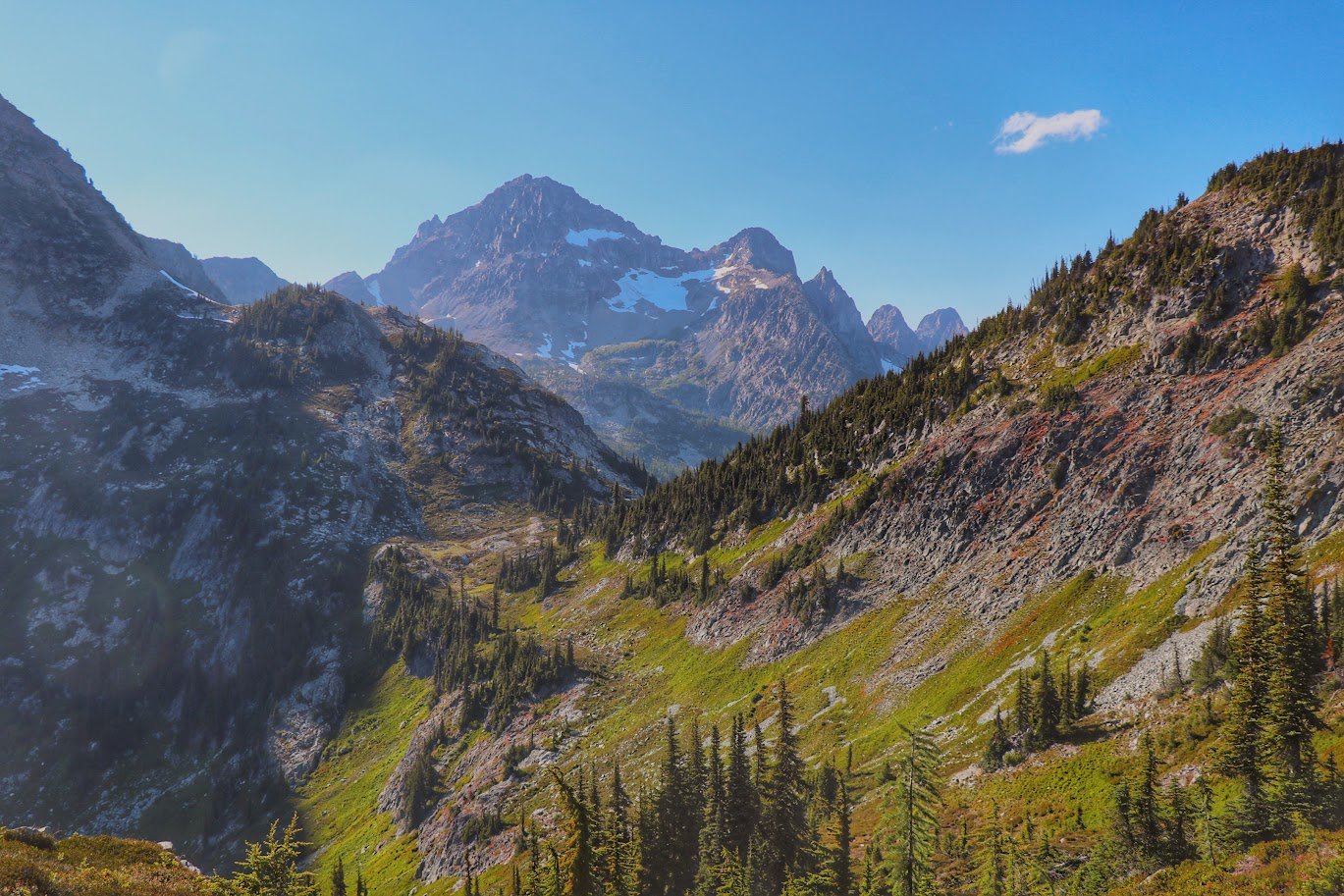
This section traverses an open ridgeline with breathtaking panoramic views in every direction. The climb continues steadily but more gradually now, with a few narrow sections along a sloping scree hillside. The trail eventually tops out at Maple Pass, the highest point of the loop at around 6,600 feet.
Here, you’re surrounded by North Cascade giants—Black Peak, Corteo Peak, and the layers of jagged ridges that make this region so stunning. It’s windy and exposed, but on a clear day, the views are unbeatable.


Mile 4.1–6.0: Descent Along the Ridgeline

The terrain on the Heather-Maple Pass Loop trail offer diversity.
Remember all that elevation you gained gradually on the way up? You’ll give it back—quickly. From Maple Pass, the trail begins a steady and sometimes steep descent back into the forest, tracing a dramatic ridgeline with sweeping views of the entire loop below.
In the fall, this stretch is prime “larch madness” territory. Golden alpine larches light up the hillside, contrasting beautifully with the surrounding granite peaks and crisp blue skies. I’ve personally avoided this trail during peak larch season because of the crowds, but I’ve hiked it both in the summer and in late September. While the larches hadn’t quite turned yet, the trail was already shifting—bright greens fading into rich reds, golds, and browns. It feels like a completely different hike as the seasons change, and I still find myself captivated by the fall colors.

The descend back to the trailhead during sundown.
Mile 6.0–7.2: Return to Trailhead
The final mile or so winds through dense forest once again. The descent is a bit easier here—less steep and more forgiving on the knees. You’ll cross a few creeks and wooden bridges before closing the loop and returning to the Rainy Pass Trailhead.
Optional Add-On
📍Lake Ann Spur Trail
If you have the time and energy, the spur to Lake Ann (off the early part of the trail) adds a peaceful alpine lake stop to your loop and is especially lovely on a calm morning.
Conclusion


Each time I hike the Heather–Maple Pass Loop, I’m reminded why it’s considered one of Washington’s best. It’s the kind of trail that packs so much beauty into just a few miles—tranquil forests, sparkling lakes, wildflower meadows, dramatic ridgelines, and those endless North Cascades views. Whether you catch it during peak summer bloom or the early signs of fall, the landscape always feels like it’s shifting into something new. Even after doing the loop more than once, I still find myself stopping to take it all in. If you’re looking for a hike that truly showcases what the North Cascades have to offer, this one’s a must.
Resources:
🌲 Wilderness Regulations - USFS resource on wilderness regulations
🌲 Heather-Maple Pass Loop on Washington Trail Associations (WTA)
🌲 Heather-Maple pass Loop on USFS Website