
The 20 Best Hikes in Washington: A Local's Personal List

Southbound of the Pacific Crest Trail (PCT) near Chinook Pass - right at the junction to the Naches Peak Loop trail.
With thousands of incredible trails to explore, Washington offers endless hiking opportunities. Even after 16 years of living in the Seattle area, I’ve only scratched the surface—there are still so many trails I have yet to experience, including some of the most popular ones. This list is a personal collection of hikes that I have done and have stood out to me. My goal with this post is to inspire your next adventure. I hope these trails bring you as much joy and ‘trail magic’ as they have brought me.
Olympic Peninsula

I love visiting the Olympic Peninsula in the off season. It is truly a breathtaking blend of rugged coastline, dense temperate rainforests, and towering mountains. Home to Olympic National Park and the Olympic National Forest, it offers endless hiking opportunities. Beaches, rainforests, summiting peaks, or backpacking through the wilderness, the Olympic Peninsula’s diverse landscapes make every adventure worth it.
1. Royal Lake

Upper Royal Lake - the gateway to the true Olympic Wilderness.
Trail stats
Royal Basin via Royal Lake is located in Olympic National Park and it is a stunning journey through lush old-growth forests, meadows with wildflowers (in summer(, and rugged alpine scenery.
The trail begins at the Upper Dungeness Trailhead and has plenty of parking spots — it also shares the trailhead with other popular hikes such as Marmot Pass and Tubal Cane. The first 4 miles of this hikes very gradually ascends alongside the Dungeness River before the climb begins up to the pristine waters of Royal Lake.
I highly recommend hiking up the well-traveled boot path to the upper basin as it offers breathtaking views of tarns and dramatic rock formations.
This might be a little long for a day hike, but definitely doable, especially if you’re unable to secure backcountry permits for an overnight.
2. Enchanted Valley
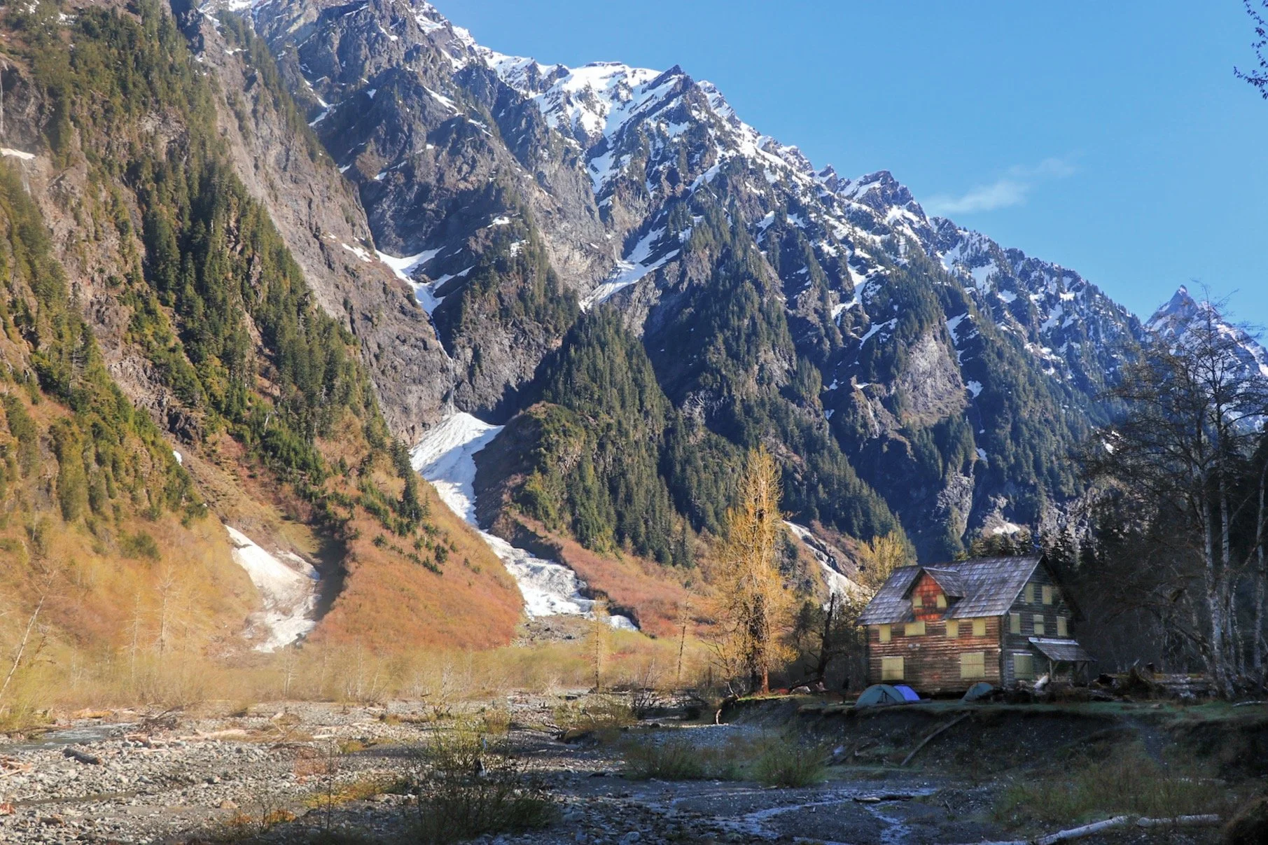
The famous chalet located in Enchanted Valley.
Trail stats
Have you seen the photo of a chalet with snow-capped mountains as the backdrop? Chances are, you were probably looking at the Enchanted Valley Chalet. The hike truly feels like stepping into a fairytale. The Enchanted Valley hike winds through towering old-growth forests, alongside the East Quinault River, and into the heart of Enchanted Valley — where waterfalls tumble down moss-covered cliffs, and the iconic chalet stands as a quiet sentinel of the past. It starts at the Graves Creek trailhead near Quilcene. The road is a little bumpy but it is suitable for any type of car.
Have you ever stumbled upon a photo of a chalet with snow-capped mountains as the backdrop? Chances are, you are probably looking at the chalet located in Enchanted Valley. The Enchanted Valley Trail truly feels like stepping into a scene out of a fairytale. It winds through towering old-growth forests, alongside the East Quinault River before entering into the heart of Enchanted Valley. Here, you will find waterfalls tumbling down moss-covered cliffs, and the iconic chalet standing quietly as well.
Hiking to Enchanted Valley via the East Quinault River is long, but every mile is worth it. While the grade is generally mellow, there are a lot of rolling hills. The first 9 miles of the hike can feel a little boring. However, once you start getting closer to the valley, the scenery changes and opens up to meadows. The hike is known for black bear sightings and I did see a few of them! I also a few elk on the hike in.
The hike begins at the Graves Creek trailhead near Quilcene. The road is a little bumpy but it is suitable for all types of cars.
3. Lower Lena Lake


Length:
7.2 miles roundtrip
Elevation Gain:
1300 feet
Pass:
America the Beautiful or NW Forest Pass
Best Seasons:
April to October
Trail stats
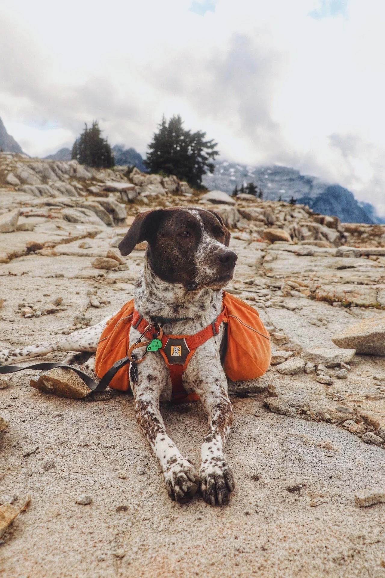
Lower Lena Lake is a year-round hike that’s both accessible and rewarding. This 7-mile hike is located in the Olympic National Forest. Since it’s not within the national park boundaries, this trail is dog friendly. It steadily climbs through lush, moss-covered forests, and crosses a few wooden bridges and offers glimpses of the surrounding peaks before reaching Lower Lean Lake.
Many people enjoy this as a day hike but this is a also a fantastic trail for first-time backpackers. With plenty of rocky outcroppings and plenty of campsites to choose from, it is.a great place to enjoy a snack, dip your feet in on a warm, and set up camp for the night. My dog, Tex definitely enjoyed standing on the outcrops while I enjoyed a snack.
4. Mount Storm King

My friend Micah, on top of the rock outcrop at the very top of Mount Storm King, overlooking Lake Crescent.
Trail stats
I’ve only done this hike once and it was back in 2019. And that was also about the time that I started getting serious about hiking and yet, Mount Storm King still kicked my butt. Much of the trail was still covered in snow when we did this hike in late February. I didn’t own any micro spikes or snowshoes. The trek up definitely felt tiring, but the views up top were so worth it.
This is no doubt one of the prettiest hikes in the Olympic Peninsula — the trail is short but a brutal leg burner with fantastic views. The 4-mile hike may not be long, but the switchbacks felt relentless, and the steep terrain will make your legs burn. Just when you think you are nearing the top, the rope section appears — giving you a final, thrilling scramble to earn the iconic view of Lake Crescent far below.
North Cascades

The North Cascades is one of my favorites to explore. This area is pure magic — jagged peaks, glacial valleys, and some of the most stunning lakes you will ever experience. Trails like Ptarmigan Ridge offer close-up views of Mount Baker (Koma Kulshan), while the Maple Pass Loop delivers one of the best panoramic views of the Cascade Range in the state. Grasshopper Pass, tucked deep in the Pasayten Wilderness, is also an absolute gem in the fall when the larches turn gold.
Many trails here are dog-friendly as well, so your pup can enjoy the adventures too!
5. Chain Lakes Loop

Trail stats
I've done Chain Lakes more times than I can count, and I'll keep going back. Yes, it gets crowded in summer — but it's a banger for relatively low effort and the payoff is hard to argue with.
The trail itself isn't too difficult, but don't let that fool you — Herman Saddle is a legitimate leg burner, especially if you're carrying an overnight pack. I start at the Austin Pass Picnic Area and tackle Herman Saddle first, which means the hard part is done early and you're rewarded with unreal views of both Mount Shuksan and Mount Baker. From there it's a descent to Hayes Lake, and the rest of the loop is comparatively easy.
If you want to make it an overnight, there are two campsites: a few spots at Hayes Lake and another few at Mazama Lake. Both fill up fast in July and August, get an early start if you want a designated site! If not, remember to only camp on durable surfaces.


6. Ptarmigan Ridge

Trail stats
Ptarmigan Ridge is another hike I keep coming back to — I’ve done it a total of three times, and all of them were overnights and it’s always worth it. Similar to the Chain Lakes Loop, I always start at the Austin Pass area — the trail offers nonstop alpine views as it winds along a scenic ridgeline. It’s about a 9-mile hike out and back to Camp Kiser with 1800± of elevation gain.
There are a few great camping spots along the way: 1) Goat Lakes, 2) the ridge before descending to the lakes, and 3) Camp Kiser. If you are up for a longer day hike, you can continue past Camp Kiser and head up to Portals East. This section is unmaintained and gets a little bit scrambly but the close-up view of Mount Baker makes this section totally worth it.
Best done in late summer or early fall once the snow melts out. Wildflowers, epic sunsets, and Mount Baker practically in your face the whole time, it’s a stunner and why I keep returning to it.


7. Winchester Mountain Lookout

Trail stats
Winchester Mountain Lookout is another banger in the North Cascades. It’s also one of those hikes that delivers way more than what you’d expect for the effort. I camped at Twin Lakes (a first come, first served campground at the base of Winchester Mountain and did this as a sunrise hike. The views of Mount Baker and the Cascade Range were absolutely breathtaking and the sunrise was hands down one of the most beautiful ones I’ve experienced. The trail is short and well-maintained, about 3.4 miles round trip but it does gain 1300± of elevation gain.
Getting to the trailhead is a bit of a mission — the road up to Twin Lakes is rough and definitely requires a high clearance vehicle, ideally equipped with AWD. If you are planning to catch sunrise, camping at Twin Lakes is a great option. The lookout itself is also first-come, first-served. I didn’t stay in it but knew a couple that was just heading out at around 7:00am. Whether or not you stay overnight, the panoramic views from the top are absolutely worth the effort.


8. Heather - Maple Pass Loop

Trail stats
Okay, do y’all see what I mean why the North Cascades is my favorite area to explore? Every hike I’ve done here is so beautiful and it makes total sense that most of the hikes on this list are located in this area too.
The Heather-Maple Pass Loop is definitely considered one of the classic hikes in Washington state and for good reasons as well. In recent years, crowds have been flooding to this trail in the summer and gets extremely popular in the fall for the larches. I was lucky to enough to encounter almost no one on the trail when I first did this hike in August 2020. However, despite how popular this trail is, I wouldn’t categorize it as easy. It gains elevation steadily once you depart the forest and up to the ridge.
I have hiked the Heather-Maple Pass Loop a few times. The last time was my favorite when I hiked up there for sunset. Tex and I got to the high point right as the sun was beginning to set and it was absolutely magical. Unfortunately, I did see a fire burning from a distance, I could see the smoke but it didn’t obstruct any views. Every time I do this hike, I feel so blessed to be able to call Washington home.


9. Grasshopper Pass

Grasshopper Pass showered by golden larches. You can see the faint trail guiding us to our destination for the day!
Trail stats
Grasshopper Pass is a hidden gem in the North Cascades. I opted for this hike to catch some larches because I knew the other popular trails were going to be packed. Grasshopper Pass isn’t the most accessible due to its location and the rough road to get up there. To get to the Brown Bear trailhead, you get to drive on one of the most exciting roads in Washington, Hart’s Pass. I felt a little underwhelmed by the road because I was really expecting some steep drop-offs but I felt safe the entire time. The road is rough but very doable for all types of cars. I stopped by Goats Beard Mountain Supplies to ask about road conditions. You can also call the ranger station to check road conditions.
There are several campgrounds along Hart’s Pass Road. I stayed at the Meadows Campground the night before. This campground is first-come, first-served and there is a pit toilet. The area was clearly burned and you can see remnants of burned trees but it was still absolutely beautiful. The drive to Mazama from Seattle is rather long, so I recommend camping in the area the night before.


10. Blue Lake

Trail stats
Blue Lake is yet another hike I’ve done at least twice. My friend Caroline and I tackled it by bringing our Kokopelli packrafts up for a paddle. We did this in October and it was actually quite chilly. I wanted to take some photos of her and her dog, Milly while the larches were slowly fading. I think this hike would’ve been better as a sunrise hike based on how the sun hits the surrounding peaks.
This hike is just as popular as its counterpart, the Heather-Maple Pass Loop trail. This one feels significantly easier and just as rewarding at the end. I recommend starting this hike early or late. We got to the trailhead after 2pm and was able to wait in the lot for a little bit as hikers that got an earlier start began to leave.


11. Artist Point Snowshoe

Trail stats
Artist Point is great for summer recreation but turns into a winter wonderland for recreation as well from November well into early July sometimes. I’ve always loved coming to the Mount Baker area because the views here are simply amazing. A lot of these trails are also dog friendly and Tex and I have been spending a lot of time exploring this area!
I’ve attempted to snowshoe up to Artist Point maybe like 3 or 4 times at this point. I’ve always had to turn around due to weather conditions. I was finally able find a nice weekend in April with promising weather to tackle this winter snowshoe adventure with some friends.
Before heading out in the winter months, always check avalanche conditions. Download an offline map and be prepared to do some wayfinding if the weather turns sour. While there are many established boot paths most of the time, there are some days after a fresh pow day that might wipe those boot paths out.
In the winter, this area becomes a winter recreation area. To park overnight, you would need to purchase an overnight parking pass. This can be purchased from the official resort website for Mount Baker.


Central Cascades

The Central Cascades are a true gem that shine brightest in the warmer months. While areas like Stevens Pass are known for their ski scenes, the region’s trails on both the west and east sides come alive in summer and fall. You’ll find everything from lush forest walks to open ridgelines with panoramic views, alpine lakes, and bursts of wildflowers—or golden larches if you time it right. It’s the kind of place where you can pick your own adventure, whether you're after a mellow day hike or a longer, more rugged trek. If you're exploring must-do hikes in Washington, the Central Cascades are absolutely essential.
12. Tank Lakes, East Fork Foss - Necklace Valley

The classic view of Tanks Lakes via the East Fork Foss - Necklace Valley trail.
Trail stats
Tank Lakes has been on my hiking list for a while and I was finally able to do it in the past couple of years. My friend Ryan and I decided to this as a 3-day, 2-night backpacking trip.
The weather forecast wasn't looking great, but we still caught some blue skies on the trail. Camping options along the route are plentiful — the first spot appears around mile 5, a large open area next to the East Fork Foss River with an alleged pit toilet (I never actually found it). After mile 5, the elevation gain kicks in hard. Push through and you'll reach Jade Lake, a beautiful spot to camp for the night.
We set up at Emerald Lake instead, which made the day hike up to Tank Lakes the next morning a lot more manageable. I won't sugarcoat it — this trail is hard, especially the climb to Jade Lake, and this was after I'd almost summited Mount Baker that same summer. But the rewards are absolutely worth it. My one regret? Not pushing further and camping at Tank Lakes itself.
13. Lake Valhalla

Overlooking Litchenberg Mountain and Lake Valhalla on Mount McCausland
Trail stats
I’ve been avoiding Lake Valhalla for a while but on one fine July night, I decided that it was time to finally do this hike, for sunset!. This hike feels straight out of a fairytale — crystal-clear water and mountain views that make you want to stay a little a while. I started at the Smithbrook trailhead, which is a shorter trek compared to starting from Stevens Pass via the Pacific Crest Trail (PCT). This hike a a steady but manageable climb through lush forest that opens up to sweeping views as your near the lake.
This spot is especially stunning in fall when the hillsides turn red and gold, but it’s a solid go-to all summer long for a mellow adventure with a big payoff. Pack a snack, maybe even a swimsuit, and don’t be surprised if you end up staying longer than planned!
14. Heybrook Ridge

Trail stats
Heybrook Ridge was exactly what I was looking for — a sunset hike without committing to miles of hiking back in the dark. At 3.3 miles round-trip with 775 feet of elevation gain, it's the perfect length — close enough to Seattle, short enough to time with golden hour, and easy enough that Tex and I could actually enjoy it instead of just survive it. (We even stopped for a full photoshoot on the ridge. No regrets.)
The trail winds through beautiful mossy forest before opening up to sweeping views of Mount Perseus and Mount Index rising above the Skykomish River Valley, the kind of reveal that makes the entire hike and drive worth it.
If you want to extend the day, the nearby Heybrook Lookout Trail adds a quick climb to a historic fire tower with even more of those views. But honestly? The ridge alone is plenty.


Close to Seattle

The I-90/Snoqualmie Pass corridor is one of the most accessible and trail-packed regions in Washington—just about an hour from Seattle but packed with enough hikes to keep you exploring for seasons. From forested lake strolls to steep scrambles with summit views, there’s something for everyone here, whether you're new to hiking or looking for a solid challenge. It’s a go-to for quick weekday escapes or spontaneous weekend adventures, with trails that shine in every season—wildflowers in summer, golden leaves in fall, and even snowshoe options in winter. If you're building your Washington hiking list, the I-90 corridor is a must.
15. Annette Lake

Trail stats
Annette Lake surprised me, in the best way possible. I’d seen photos and never felt super drawn to it, but in the winter, it’s a whole different experience. The trail is about 7.5 miles roundtrip with 1800± feet of gain, mostly mellow with a few short, steeper sections.
We had perfect weather when we did this hike, with the sun breaking through and lighting up the snow-covered trees. Microspikes were helpful in the winter months. The trail passes through some avalanche chutes so avoid this hike entirely if the avalanche dangers are rated as moderate to high. Once we got to the lake, we had the lake completely to ourselves and were able to walk on it as it was completely frozen.
In the winter, the trailhead becomes a Sno-Park so a Sno-Park permit will be required to park here. There is a privy at the trailhead and the road to the trailhead can be easily accessible by any type of car.
This is a beautiful and peaceful hike and really do shine in winter.


16. Snow Lake

Trail stats
Snow Lake is classic hike that’s popular for a reason — easy access, stunning views, and a big payoff without too much effort. I’ve done this trail 3 times, all of them were overnight trips. The trail is about 7.2 miles out and back with 1800 ± feet of elevation gain. The switchbacks can feel a little relentless at times, but the views at the end make you forget about the struggle.
Once you crest the ridge and catch that first glimpse of the lake, it becomes pure magic. I’ve camped at several different spots and campsites are scattered around the shoreline. If you are willing to wander a bit further, you can find quieter spots away from the crowds.
17. Rattlesnake Ledge


Trail stats
Rattlesnake Lake is the kind of hike that’s perfect when you want something quick, scenic, and close to Seattle. The trail to the ledge is about 4 miles round-trip with 1,160 feet of elevation gain, and it’s a steady climb with plenty of switchbacks to get your legs working. At the top, you’re rewarded with a stunning view overlooking the lake, surrounding forests, and the Cascades in the distance.
It is SUPER popular — especially on weekends, so I recommend going early or on a weekday if you want a little people on the trail with you. A Discover Pass is required to park in the Rattlesnake Lake Recreation Area but I think there is a small lot before the gate where you don’t need a pass. I’ve also seen cars lined up on both sides of the road before heading into the recreation area.
I personally enjoy doing this as a sunrise or sunset hike. I also enjoy coming here for a paddle after work at Rattlesnake Lake. I have yet to hike then paddle. Perhaps next time?
South Cascades/Mount Rainier

When I talk about the South Cascades here, I am including the Mount Rainier area too. This is actually the area I visit the least aside from Eastern Washington (Wenatchee and beyond). Mount Rainier definitely steals the show the majority of the time but ever since I got a dog, it’s been hard to plan trips and hike within the national park boundaries. However, there are still a few that offers great views of everyone’s favorite mountain in Washington state.
18. High Rock Lookout

High Rock Lookout is a short but rewarding hike with one of the most dramatic viewpoints in the South Cascades without being inside of Mount Rainier National Park, which is why I love this hike, because Tex is allowed on this trail.
The hike is about 4 miles roundtrip with roughly 1350 feet of elevation gain, climbing quite relentlessly through a forest before opening up to a rocky summit with a historic fire lookout perched on the edge of a cliff. The views of Mount Rainier, Mount St. Helens and Mount Adams, and the surrounding valleys are absolutely unreal, especially on a clear day! Volunteers are currently working to restore the lookout, so please be respectful of that.
No parking pass is required to park here. The forest road to get there is rough. High-clearance is very helpful, and it’s best to check conditions ahead of time. The trail is typically snow free and best hiked from late June through early October. It’s a quick trip with a quick payoff for sunrise or sunet.


19. Snowgrass Flat, Goat Lake, Jordan Creek

Snowgrass Flats overlooking Mount Adams.
Trail stats
The last time I visited the Goat Rocks Wilderness was back in 2021 — a lot of the permits we obtained fell through due to wildfires, so we deiced to head over to Goat Rocks. We completed the pretty standard loop that hit some of the most popular spots in the area. We started our hike at the Berry Patch trailhead, traveled up to Snowgrass Flats and completed the loop, passing Goat Lake and Jordan Basin before we headed back our car.
This area is beginning to see more usage and an uptick in backpackers so it is extra important to only camp at designated areas or sites have been clearly used. I wish we had more than one night to explore Goat Rocks Wilderness because there is so much more to see, but there’s always next time!
20. Dege Peak

Dege Peak is often overlooked because the nearby Fremont Lookout trail gets all the hype.
Trail stats
Before Tex came into my life, Dege Peak was one of my go-to after work sunset hikes. Sadly, dogs aren’t allowed on hiking trails in national parks, so this one is on the solo list for now. It’s still one I hope to go back to. There’s something about the quiet up here that’s hard to find elsewhere, and the late afternoon light is genuinely special for photography.
Located in the Sunrise area of Mount Rainier National Park, Dege Peak is one of the easiest ways to earn one of the best views of Rainier without a massive effort. The trail follows a ridgeline with nonstop views of surrounding peaks and wildflowers in summer, and it’s a great way to dodge the crowds that funnel toward Fremont Lookout. I’ve brought two friends up here and both times it delivered. I even saw the milky way one time when I was heading back to the parking lot.
If you’re looking for a mellow hike with a huge payoff, especially in golden hour — this is it!
Final Thoughts
I might be biased but Washington’s trails have a way of making you incredibly small in the best way possible. After almost 18 years of exploring this state, I am still finding new ones that stop me in my tracks. This list is personal, imperfect, and nowhere near exhaustive, but every single hike on it earned its place and most of them are Tex-approved as well. Whether you’re planning your first overnight or looking for a new sunset hike close to Seattle, I hope it gives you somewhere to start.
And if you're still planning your Washington adventures, head over to my Washington Adventures Hub — it's the best place to find more trip reports, guides, and hiking inspiration across the state.
Have a trail you think deserves a spot on this list? I'd love to hear about it in the comments!