
Chelan Lakeshore Trail

Views overlooking the Cascades on the way to the Stehekin Bakery
I guess the normal turnaround time for me to write a post is about 3 months after I’ve completed a trip. Life has been busy and I am trying to pack my schedule to the max because summer in the Pacific Northwest arrived later than normal this year. While everyone was pretty upset about it, I was actually pretty grateful for that because whenever the weather gets hot and dry, it also signals the arrival of wildfire season and nobody wants that, right?
I completed section of the Lakeshore Trail (also known as the Chelan Lakeshore Trail if you’re trying to look it up on Google) back on Memorial Day Weekend. While it wasn’t the first backpacking trip I did for the season, the best time to do this trail is generally in the Spring due to how exposed most of the trail is. In this post slash photo essay, I will go through the details of how to get there (hint: it involves a ferry) and how the trail conditions were when I did this back in May.
Without further ado, let’s get to it 👇
Trail Overview
Getting to the Trailhead
The Ferry Ride and FAQs
Day 1: Moore Point to Flick Creek
Day 2: Flick Creek to Stehekin
Exploring Stehekin
Resources
Distance (one way):
17 miles (I did 7.5 miles)
Area:
Lake Chelan Sawtooth Wilderness and North Cascades National Park
Elevation Gain:
4030 feet
Pass:
No need for a pass as you will be parked in Chelan

Chelan Lakeshore Trail
Overview of the trail
The Lakeshore Trail is a 17 mile end-to-end trail located in the Lake Chelan-Sawtooth Wilderness. For the most part, you will hiking in the Okanogan-Wenatchee National Forest and will enter North Cascades National Park once you reach Stehekin.
To get to the official trailhead, you can access it from Prince Creek. Once if you’re on a time crunch or don’t want to do the entire 17 mile hike in a day, you can opt for starting at Moore Point which was what my friend and I did.
At the end of the trail, you will arrive Stehekin. Stehekin is generally considered to be the gateway to the more remote part of the North Cascades and an entry point to the more rugged Cascade Mountains and its surrounding wilderness area. The name ‘Stehekin’ derived from a Salishan word meaning ‘the way through’ or ‘turning around point’ in Lushootseed (Coast Salish) and ‘mountain tops’ in Nxa’amxcin (Interior Salish). The town of Stehekin only has 75 permanent residents with no roads to connect to the outside world. The only ways to get to Stehekin would be by foot, boat or plane.
There is a good document provided by the US Forest Service that provides more a more in-depth description of the trail and all the camp areas that you can camp at along the trail, that can be found here. No permit is needed to camp along the Lakeshore Trail but a dock permit is needed if you are bringing your own vessel of some sort to do the trail. Nonetheless, if you are going on a weekend like we did, be prepared to hike additional distance to find open camp spots - our goal was to sleep at Flick Creek, but unfortunately was already full by the time we got there. More details on this later.
Getting to the trailhead
The Lakeshore Trail is the one on the right, there are 6 camp areas along the way, and 2 once you reach Stehekin
To get to the trailhead, you can either hike in from Stehekin, take a boat or fly in. I opted to take the ferry as I only had one weekend to spare even though I had a long weekend. But with last minute planning, I was only able to secure tickets for leaving on Saturday and coming back on Sunday. You do want to plan ahead and book those ferry tickets. I got mine through Lake Chelan Boat Co. - which runs the Lady Express and Lady of the Lake. They have a good cancellation policy so if plans do change, you can always work them with to get a refund or potentially get them for a new date.
The Stehekin Ferry also runs ferries to drop you off at Holden, Prince Creek and Stehekin. Each company only runs one boat due to how long it actually takes to get to Stehekin and back. Lake Chelan Boat Co. has more options since they technically have 3 different types of boats to transport passengers. Both companies are dog friendly, which was great for me because I had my dog Tex traveling with me. On the website, it said pets are required to be in a crate but they didn’t actually enforce pets being in crates. I had Tex on leash and he hung out with me the entire time. There were obviously a lot of other dogs on board too.
The Ferry Ride

Lady of the Lake
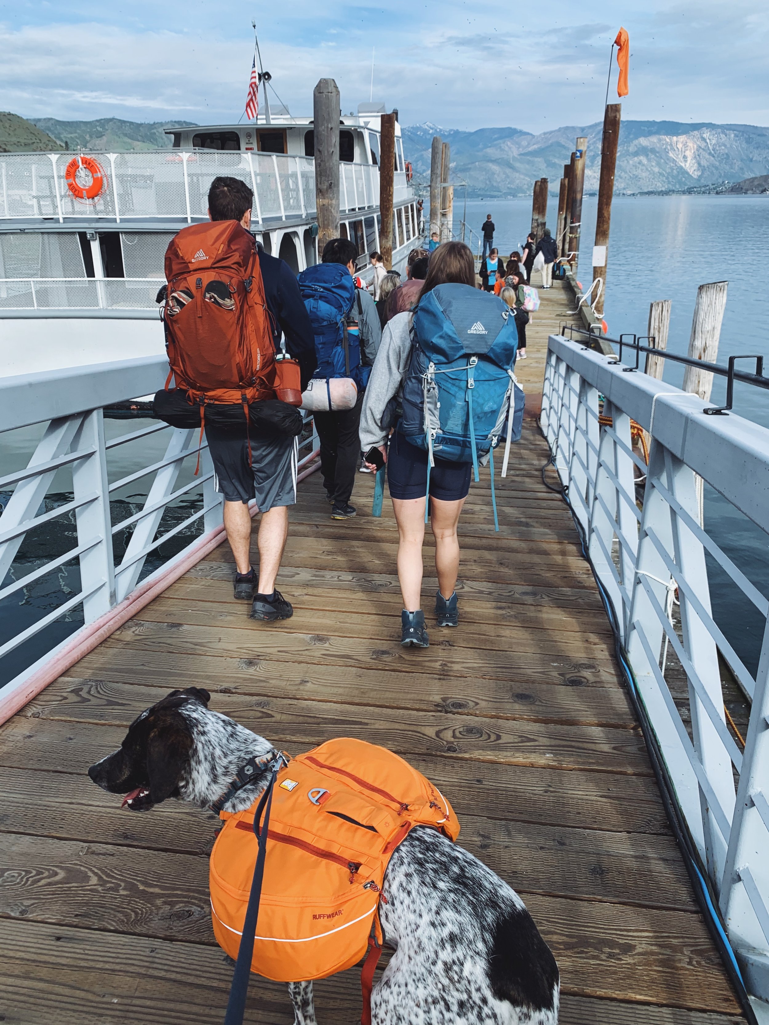
The line of backpackers boarding the boat
Where do you board the ferry? Is there parking?
Depending on which ferry you take, you will receive an email confirmation letting you exactly what time you should show up to the dock. For us, we chose to take the Lady of the Lake at 8:30am so we got to the office at around 8am just in case. There is a parking area if you are staying overnight anywhere along the Lakeshore Trail including Stehekin. We also stayed nearby at Lake Chelan State Park on Friday night so we didn’t have to get up at 4:30am to make the drive from Seattle to Chelan.
The parking area is across the road from where the boat dock is located. My advice would be to stop by the office first to pick up your parking pass and then proceed to the parking after that. I learned the hard way and had to walk back and forth twice. Parking is somewhat limited so I would advice perhaps showing up just a little bit earlier if you want a prime parking spot. Despite it being a Saturday, we were able to find a relatively good spot.
How long is the ferry ride?
To give you a good estimation - it took us about 4 hours to get from Chelan at Moore Point and that’s taking the regular Lady of the Lake. If I were to do it again, I would pay a little extra to get on Lady Express. In short, Lady of the Lake makes more stops and Lady Express is the more direct way to get to Prince Creek. The views were great but Lake Chelan is huge and on a busy weekend, you would want to get to the trailhead as soon as possible.

The stack of belongings for everyone on board - this giant pile is headed for Prince Creek

My dog enjoying the ferry ride
What was the ferry ride like?
As you are boarding the ferry, there will be staff checking for your tickets and also asking where you’re headed. This is so that you know where you will be dropping off your belongings. You’re not allowed to take large bags like suitcases or in our case, backpacks with you so you would have to leave them at the front of the boat. I would grab water, snacks and anything you want on your boat ride with you as access to your belongings become limited as more people get on board. We went at the end of May - while it was mostly sunny, it definitely got chilly on the ride so I also recommend taking a jacket with you.
They also sell snacks and coffee on board as well. There is a bathroom too.
Is it dog friendly?
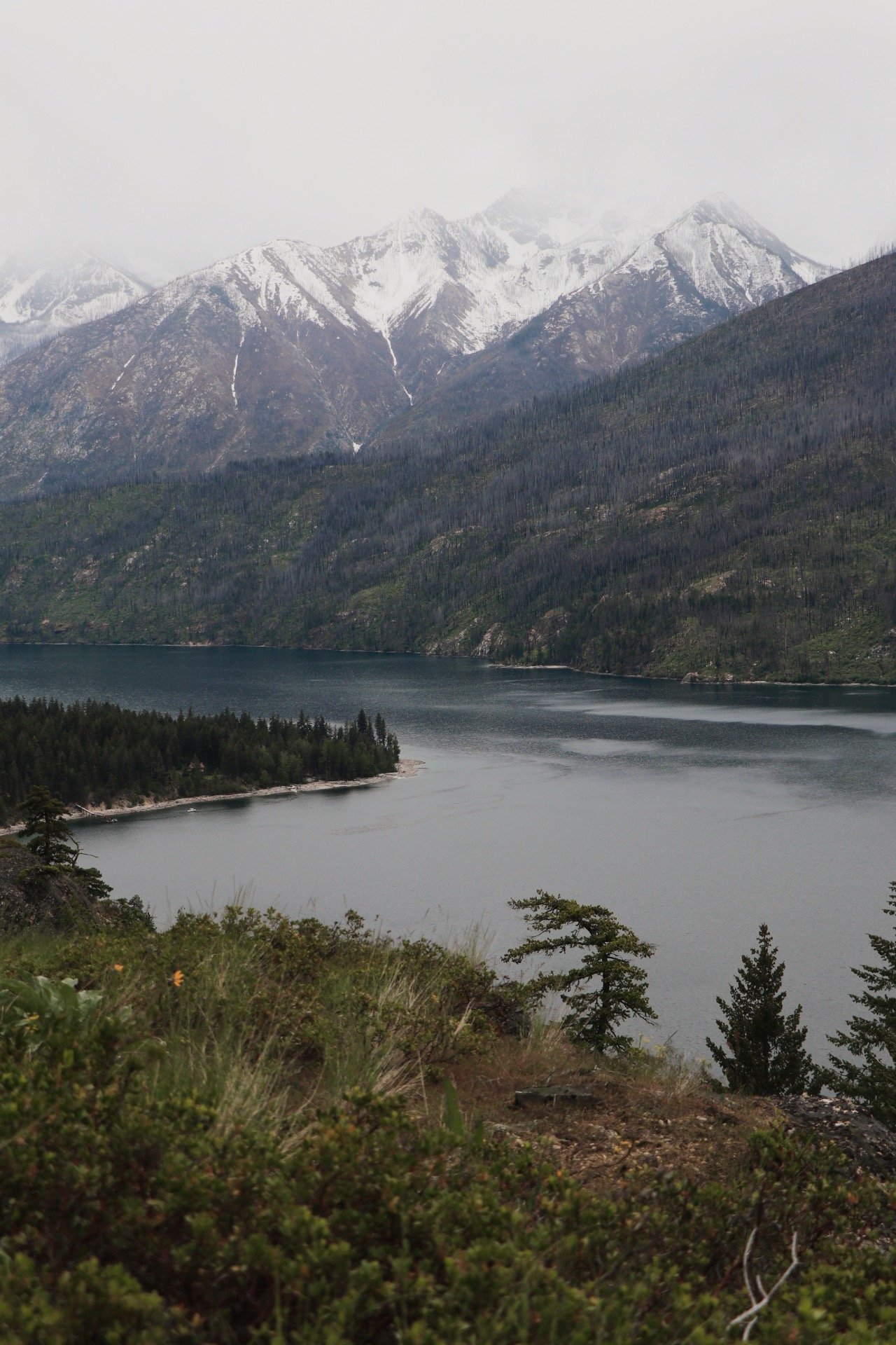
Briefly mentioned above, I had no problem taking my dog up to the ferry. He boarded like a regular human and hung out with me the entire time. Despite him being an anxious dog, I think he enjoyed the boat ride as much as I did. This was my first time visiting Chelan and man, the views were amazing. As the ferry departed the dock, we passed through several small towns along the way. After leaving the inlet, we were entering the real wilderness. Snow-capped peaks towered on both sides of the water.

Heading into the wilderness!
Moore Point to Flick Creek
4 miles, ~1500 feet of elevation gain
Oh yeah, we really took it chill on this trip. My friend had a looming leg injury that some days are good and some days, he really had to take it easy. After we got dropped off at Moore Point, we got situated with our packs and was well on our way. Despite Moore Point because the second stop on the Lakeshore Trail, there were still a good amount of people that dropped off here. In my head, I really wish they were trekking all the way to Stehekin. From online sources, I knew there was only one spot at the Flick Creek camp area. We’d be lucky if we were able to grab that spot.
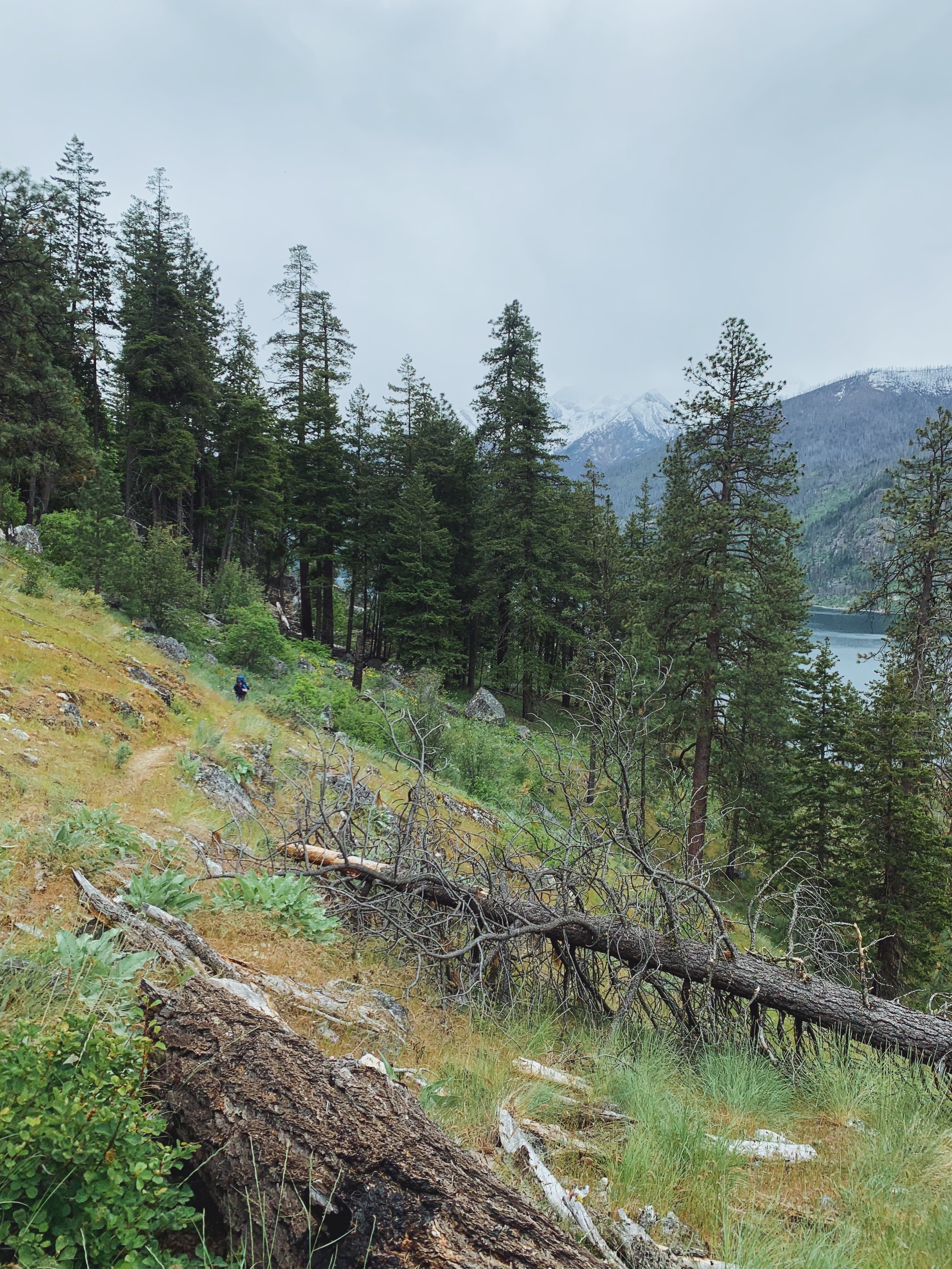
The good news about the trail was there was nothing technical about this trail. While you would be gaining and losing elevation, nothing felt strenuous because you would be getting great views along the lakeshore of Lake Chelan the entire time. Some parts were a little dusty and rocky but with some trekking poles or sturdy shoes, you would have no problem hiking on this trail.

Views on views on views along the Lakeshore Trail

Even though we started with sunny skies at Lake Chelan, the skies were becoming more overcast as we hiked, which could also be a blessing. Most of the trail was exposed so I couldn’t really imagine this on a super hot and humid day as shade was definitely scarce on this section of the trail.
There were plenty of spots to fill up your water bladders and bottles. I opted to bring a little less water because I knew we were still pretty early in the season and that water sources would not be a problem. I always check recent trip reports to see if anyone mentions anything about water sources.
Since there wasn’t a whole lot of elevation gain (I think we skipped a lot of that by starting at Moore Point), we made it Flick Creek in a little over 2 hours including breaks and soaking in the views. As I expected, the only established campsite was already occupied. We hiked along the trail a little past Flick Creek only to find that all the other flat and bare grounds were also taken by backpackers. We knew what we were getting into when we got dropped off later (which is also why I recommend taking the Lady Express). Nonetheless, we continued hiking towards Stehekin - worst case was we try to find a spot when we hit Stehekin.
I believe we hiked another 1.5 or 2 miles to finally get to an open area where it looked like people had camped. There was also another group there that invited us to share the space with him (so thankful). Before we found this spot, you would actually be hiking in private property - there were clear signs and ribbon that indicated where you were allowed or not allowed to camp. We passed by multiple sites that looked like they had potential only to find out that we weren’t allowed to camp there.
Because this was my first time doing the trail and I was pretty sure the USFS would highly recommend camping at established campsites, I didn’t find too much information on additional spots along the trail so I was definitely a tad worried but alas, we found a good spot with an alright lake view and set up our gear and ready to call this place home for the night.

Am I brave enough to sleep without a rainfly?

Nah, checked the weather on my GPS and said it might rain, so rainfly is on.


This was actually the first time I took my dog out on a backpacking trip. That obviously added a little bit of stress to the entire trip. I didn’t trust him to be off leash yet but I still needed to make sure I could set up my tent and whatnot. Thankfully, there were some trees around the campsite that I could easily tether him too. After a long day, from taking the ferry to hiking part of the Lakeshore Trail, we slowly mustered our strength to make dinner. The Chicken Coconut Curry from Peak Refuel was hands down one of the best backpacking meals I’ve had in in a while and I highly recommend it to anyone looking to switch their routine up a little.
My friend and I were both exhausted and we were hoping to get up early enough to make sure we had a little time to explore Stehekin and also be there in time to catch the 2:30pm ferry. Before the sun fully set, I was already sound asleep.
Day 2: Camp to Stehekin
2.48 miles, 1146 feet of elevation gain


The hike out the next day was easy compared to the day before even though the hike in wasn’t even difficult to begin with. As you continued to hike towards Stehekin, you actually experience a little more shade than the day before. Nonetheless, the trail soon opened back up to views of Lake Chelan. Wildflowers weren’t exactly blooming at this time but I still saw a lot of lupines on the way out.
This section of the trail was pretty self-explanatory but I thought it was one of the most scenic parts of the trail. But somehow I didn’t manage to take a lot of photos on this section. Perhaps I was so fixated on getting to Stehekin so I could finally head to the bakery and fill my belly with some food since we skipped breakfast in the morning.
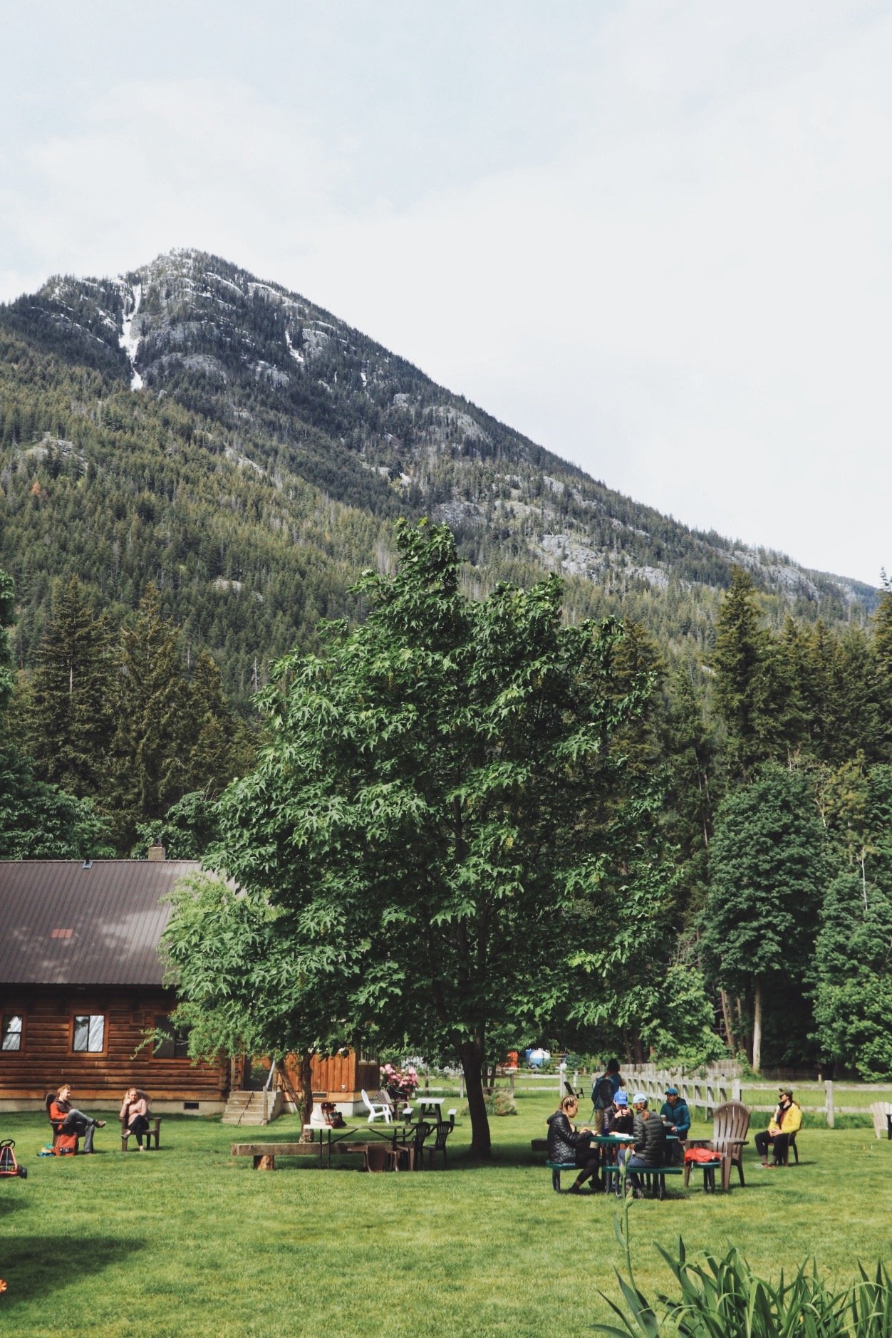
Exploring Stehekin
We made it to Stehekin!
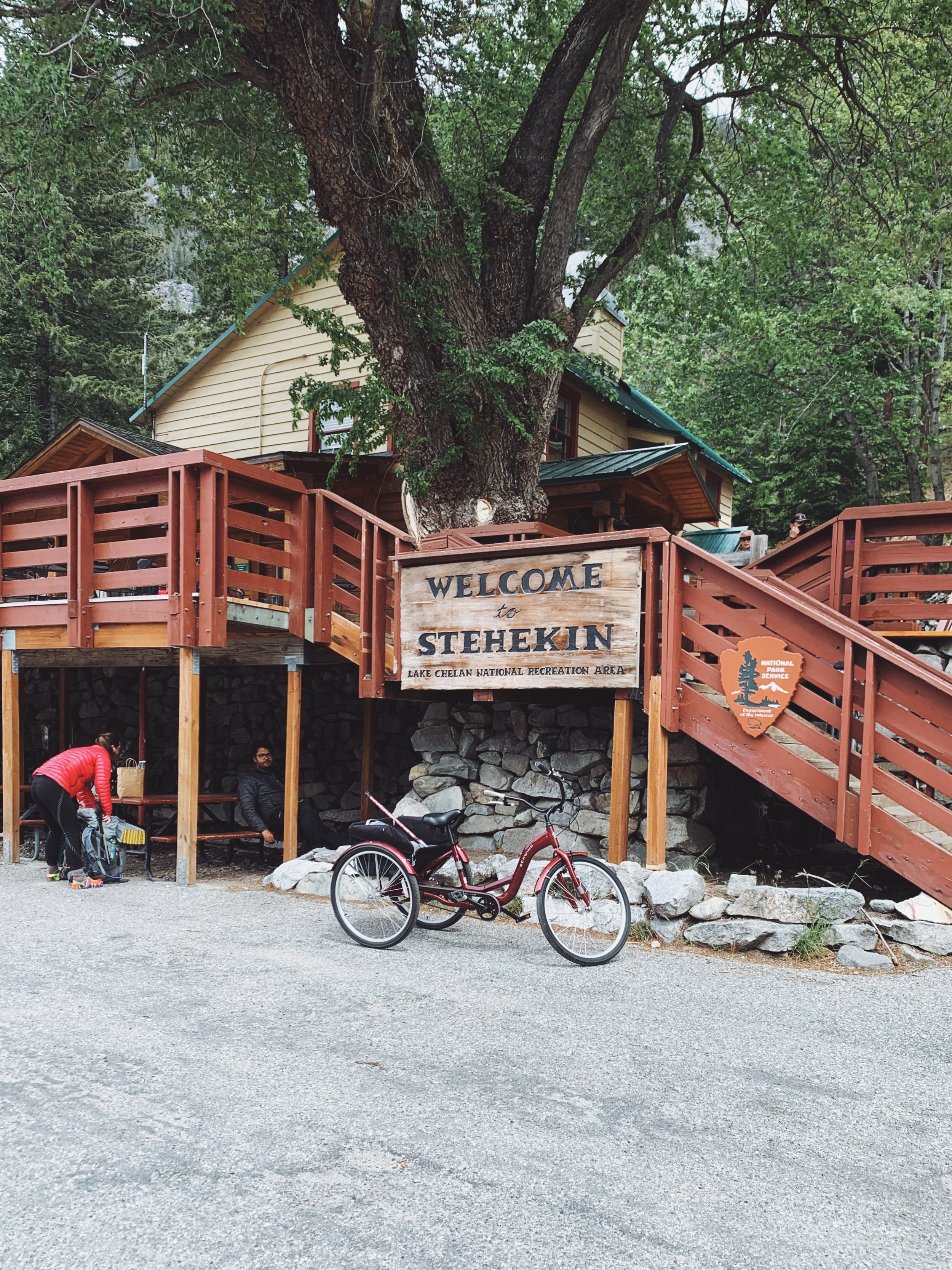
After walking for an additional 2.48 miles and gaining about ~1200 feet of elevation, we made it to the Purple Point Overflow Campground. It was a good decision to not hike all the way to Stehekin while we desperately looked for a campsite the day before because it turned out even the overflow campground was full. Nonetheless, we were officially leaving the Lake Chelan Sawtooth Wilderness Area and made our way into North Cascades National Park. The Golden West Visitor Center was also located here - assuming people would take the boat in and pick up their permits to access trails from Stehekin.
Stehekin was a quaint little town. We arrived shortly after 8:30 in the morning. The town was still quiet and slowly waking up. We were one of the few people exploring aside from the early risers that presumably ran the tours and e-bike rental stand. My friend’s leg was hurting a lot at this point. I told him I was set on headed to the the Stehekin Pastry Company and it was optional whether he tagged along or not. He decided to stay behind and so I continued on.

The Stehekin Pastry Company is located roughly 2 miles from the Golden West Visitor Center
The Stehekin Pastry Company is located about 2 miles from the Golden West Visitor Center. You would essentially be hiking along a paved road. The road actually offered great views of Lake Chelan and the Cascade Range as well. As I continued on the paved road, I started seeing more people that were on e-bikes and even a buggie - I wish I had rented a bike because although it was a scenic trek, having a pack on and an empty stomach, I wanted to get to the bakery even faster. I’m not sure what the rates were but I thought they were reasonably and to be honest, it was probably one of those touristy must-do things when you’re in Stehekin.
2 miles later, I finally made it to the bakery. I was elated. Unfortunately dogs weren’t allowed inside so I securely tied my dog Tex to one of the many picnic tables outside and headed in there. The options were endless. I literally wanted to try everything. But I knew I wanted something savory and sweet. So I picked up 3 items (one of them was for my friend who was waiting near the ferry dock).

Wish I had gotten one of these bad boys!

Ham and cheese croissant
Lots of outdoor seating if you have a dog!


By the time I finished eating, it was just a little past 11:30am. I still had plenty of time before we had to catch the ferry at 2:30pm. I also heard from one of the guys that worked the e-bike rental stand that the ferry departing at that time was known to be late. Hence, I took my time hiking back to the dock while soaking in the views of this more remote part of the North Cascades.
Resources


The Lakeshore Trail is an easy to moderate walk along the shore of Lake Chelan and I truly enjoyed doing it. I can’t speak to the section from Prince Creek to Moore Point but I heard the up and downs could be tiring to some people. All in all, I think what made this trip extra special was having to planning logistics prior to starting the hike. Like I said, if you are planning to do this hike, just make sure you plan ahead and get your ferry tickets early. I’d imagine during the peak season, a lot of those tickets could sell out fast.
I’ve compiled a list of resources that could potentially help you plan this hike if you do decide to do it when fall rolls around.
Lake Chelan Boat Co. - get ferry tickets and schedules
Stehekin Ferry - alternative to Lake Chelan Boat Co.
Lakeshore Trail Overview from USFS - good description and maps of the trail
Federal Dock Site Permits - if you do decide to bring your own watercraft and dock it
Trail Reports from WTA - I always like to check trip reports prior to setting out on a trail, gives you a general on updated trail conditions and might come in handy with finding a campsite for the night and water sources
As always, happy trails and practice leave no trace principles and recreate responsibly while you’re out there 🥾