
A Guide to Visiting Valley of Fire State Park
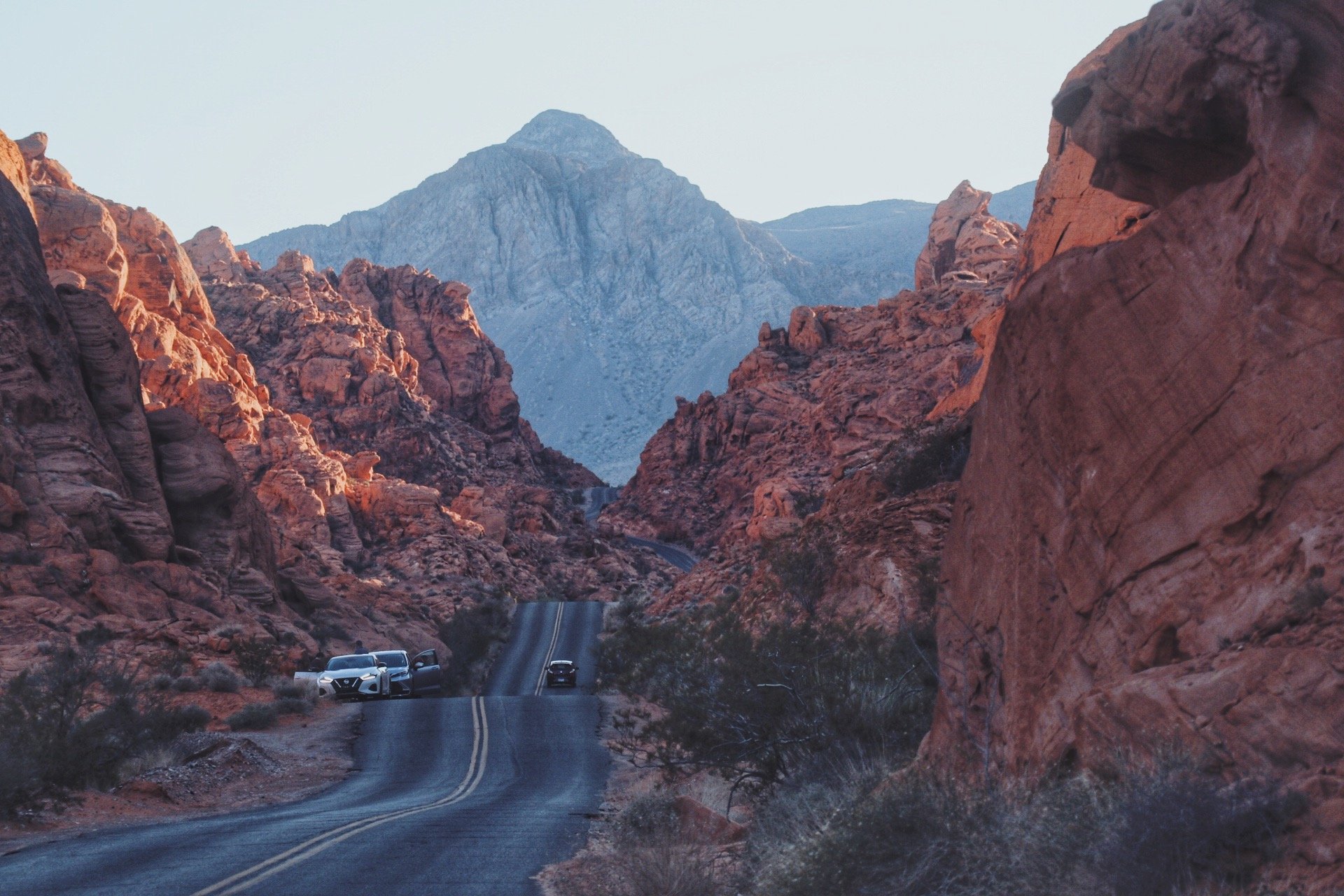
The iconic road that everyone came to take a picture of at Valley of Fire State Park.
Valley of Fire State Park has been on my bucket list of places to visit for a while now. I’ve seen lots of photos in the past of that iconic long and winding road that cuts through towering red rocks and despite the park being located only an hour from Las Vegas, I never quite had the time to truly explore this part of Nevada. So when I was planning my road trip for the winter this year, I decided that I am finally going to include this park.
Start here 👇
Overview
Fees:
$10 per vehicle (Nevada Residents) / $15 per vehicle (Non-NV Residents)
Campgrounds:
Atlatl Campground
Arch Rock Campground
Hours:
Sunrise to Sunset Daily
24-hour access to Campgrounds
Best time to visit:
The park is open daily year round but the best months to visit are October to March
Where is Valley of Fire state park located?
Valley of Fire State Park is located about an hour away from Las Vegas. The closest towns are Overton and Moapa Valley.
I’m not sure if this park is often overlooked due to its proximity to larger and more well-known landmarks such as the Red Rocks National Conversation Area and even Zion National Park. Or maybe it was because I visited during the ‘off season’ - the park never felt really felt crowded.
Though it still takes about almost 3 hours to get to the nearest national parks, you can easily make Valley of Fire State Park a stop on your next road trip. I think most people do this as a day trip when they’re visiting Las Vegas though.
History of the Park:
The Fire Wave is the main attraction of the park.
Some 2,500 years ago, Ancestral Puebloans were living in and around the modern-day Moapa Valley (located about 13.8 miles / 20 minutes away). Ancient petroglyphs were found carved into the red sandstone rock formations as seen around the park. In the mid-1860s, Mormon missionaries settled St. Thomas - this settlement was later flooded by the waters from Lake Mead during the Hoover Dam construction in the early 1930s.
In 1931, Valley of Fire State Park was created after a transfer of 8,760 acres of federal land to the state of Nevada. The park was built by the Civilian Conversation Corps, building simple amenities such as campgrounds, stone cabins, trails and roads. The park opened in 1934 and became Nevada’s first state park in 1935.
The name ‘Valley of Fire’ derived from a AAA official traveling the road connecting Salt Lake City and Los Angeles as part of the Arrowhead Trail in 1920 and due to the red sandstones, the entire region looked like it was ‘on fire’ and hence the name.
Source: Nevada State Parks and Travel Nevada
Camping at Valley of Fire State Park

Camping amongst the red sandstones at Atlatl Campground

Making breakfast the next morning
There are two campgrounds at Valley of Fire State Park and they are actually located in the same area. Both campgrounds combined yield a total of 72 available sites. I camped at Atlatl and this is where Atlatl Rock is located. A flight of stairs take you to petroglyhs on the Atlatl Rock. I did drive to Arch Rock the next morning just to check it out. I honestly would have preferred staying here instead if I had the chance to camp here again.
I read online that both campgrounds can fill up quickly even on the weekdays. Since they were both first-come, first-served, I wanted to get to the park relatively early. By the time I rolled into Atlatl Campground, it was a little after 11am. Plenty of spots were available and most of them had red sandstones as a backdrop. I wanted some privacy and some protection from the winds if there was going to be any, I opted for a campsite situated right next to the iconic red sandstones.
I wasn’t a resident of Nevada, so I paid $15 to get into the park. This counted towards the campsite fee for the night. If you don’t have cash with you, you would have to check in at the visitor center to pay with a card. Even if you do ‘forget’ to do this, the ranger will stop by in the morning and stick an envelop on your vehicle to make sure you pay the fee.
There is also a separate area for folks with RVs and those sites are an additional $10/night. These sites have electric hookups and are generally more spacious.
Things to Do at Valley of Fire State Park

If you only have one day to visit, you can easily hit up all the iconic spots in Valley of Fire State Park. The hikes within the park are all less than 2 miles long. I started my day a little later so I really only had time to do one hike but I also spent a lot of time pulling out at random spots to take photos. I even took a side trip out towards Lake Mead and the town of Overton, more about that later.
I stopped by the Visitor Center first, which is open daily from 9am to 4pm. I usually start my ‘journey’ here because 1) I like to collect souvenirs from every park I visit. I do that first so I won’t have to worry about making it back here after a day of sightseeing and whatnot since the sun would’ve most likely set by then and 2) it’s always nice to talk to the people that work or volunteer for the park because they are knowledgeable! Sometimes they can even give you tips on where to find hidden gems.
Note: It is required that you are off the hiking trails and off the Mouse Tank Road at sunset. If you don’t return to your campsite or be seen as on your way out of the park, you will be considered as trespassing. I did ask the ranger why they do that, she explained it was because that they go out and search for missing hikers if that does happen.
Hiking: Fire Wave Trail
Length:
1.5 miles
Elevation Gain:
236 feet
Where to Park?
Parking Lot 3
Pets Allowed?
Yes

The area surrounding the Fire Wave was really cool.
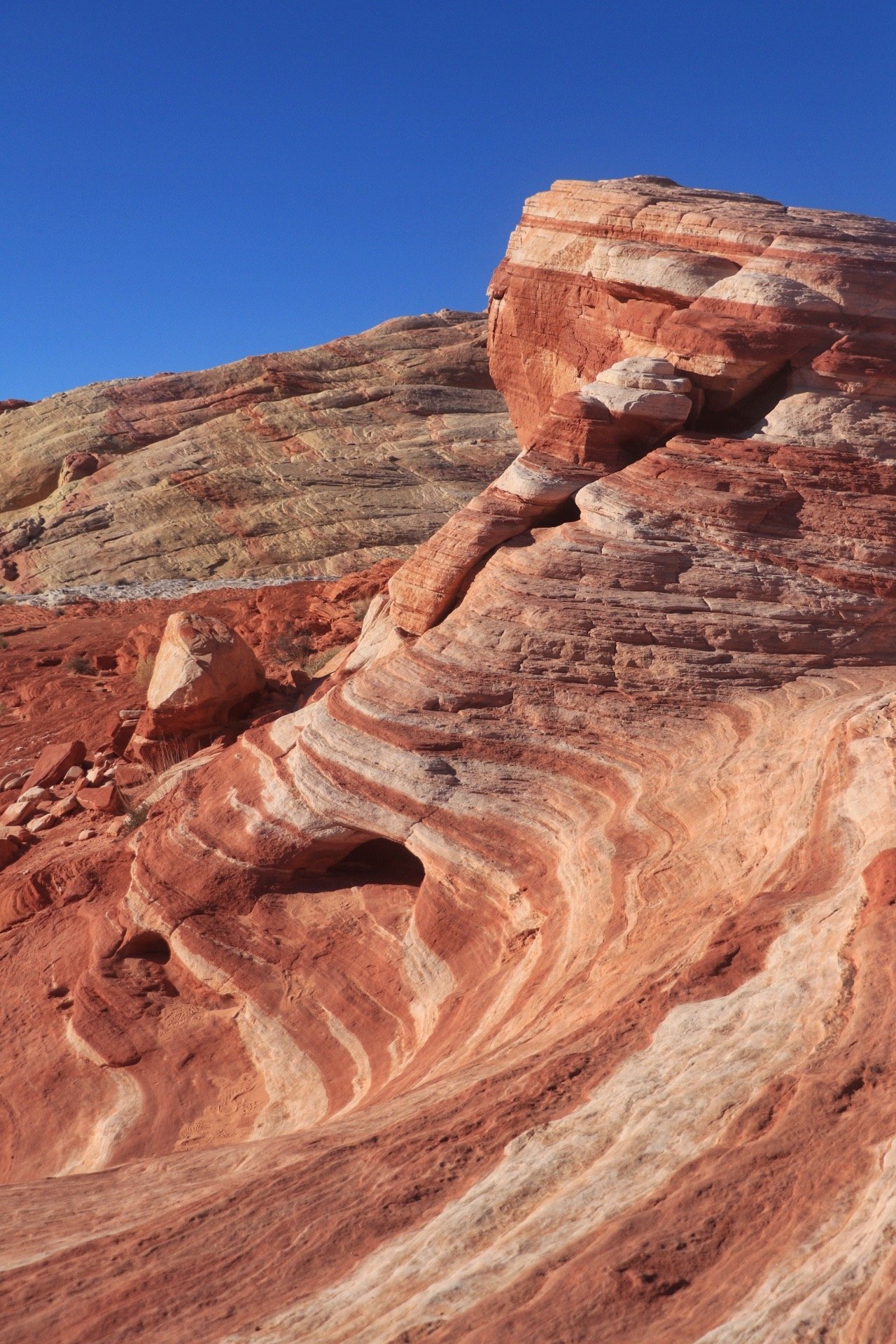
I’m 99% certain that this is probably the most popular trail in the park. If you only have time to do one hike, this will be the one. The Fire Wave is considered to be the baby cousin of The Wave (Coyote North), which is located in Arizona. That one requires winning a lottery, this one doesn’t. Even though the Fire Wave itself is not as spectacular as its counterpart, the colors and different layers that form the wave and its surrounding area was really cool. The trail is easy and is relatively well-marked. The ‘end’ of the Fire Wave trail ends at a sign that tells you that you can either turn around and keep hiking to complete the Seven Wonders loop.

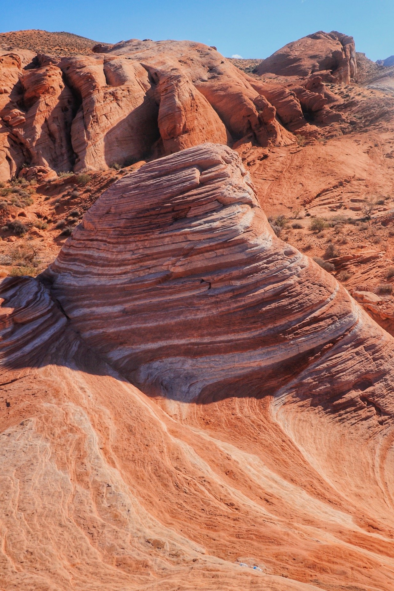

I continued past the sign that signified the end of the Fire Wave trail and went on to complete the Seven Wonders Loop. I actually enjoyed this section a little bit more than the hike to the Fire Wave because there were slot canyons! As someone that lives in Washington state, slot canyons are almost non-existent. I was hiking with my dog so I had a really enjoyable time exploring the slot canyons with him. What was most intriguing about this hike were the different colors you see on the rocks. The formations and colors of the rocks shifted from red to pinks and pastels, which was also iconic to the Seven Wonders Loop.

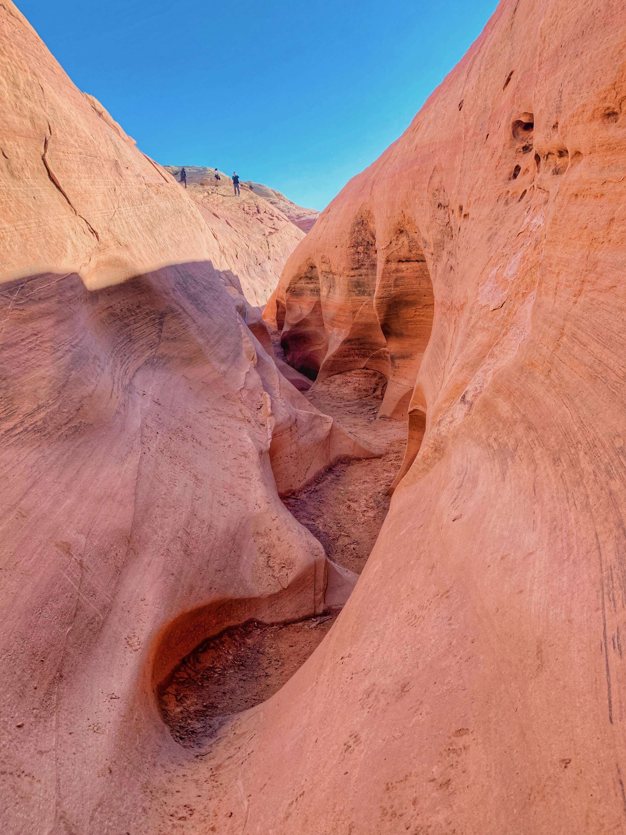

Most of the Fire Wave Trail and the Seven Wonder Loop consisted of hiking over loose sand and the occasionally small climbs over uneven terrain but I wouldn’t say any of this was difficult. In fact, my dog really enjoyed climbing over the rocks. He was a little hesitant when traversing into the slot canyons, but once he knew it was okay to proceed, I could see him enjoying and soaking in the scenery as much as I did. I stopped numerous times just to snap photos and really admire the different types of geological features.
I think the Seven Wonders Loop eventually connects with the White Domes Trail but I didn’t end up doing that trail. I did miss the sign that signaled the turn back to the trailhead for the Fire Wave Trail at first. But if you study the map carefully, you can easily tell that this trail does connect with White Domes - which according to the park brochure, consisted on similar geological features as the wave but instead of the different shades of reds, these rocks are white.
Sightseeing: Rainbow Vista
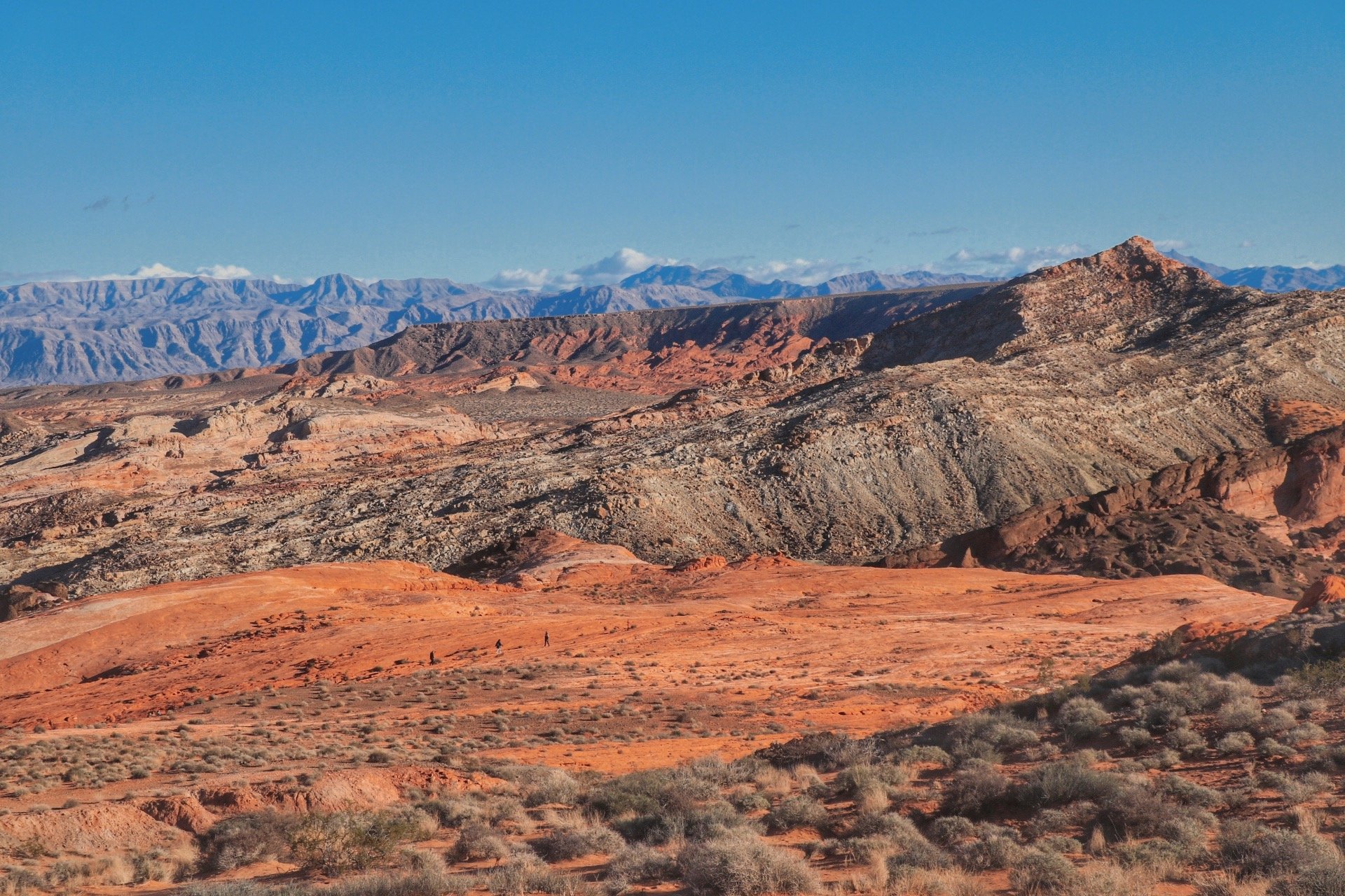
Rainbow Vista - an easy 0.5 mile trail that leads you to this view.
Not sure if I missed the memo or not, but Rainbow Vista was a little underwhelming after hiking the Fire Wave Trail. Nonetheless, the easy 0.5 mile to the end of the trail yields a great view of the entire park. I believe the mountains beyond the red rocks are considered to be park of the Lake Mead Recreational Area. I didn’t spend too much time here. I took a few photos and took some photos for a couple I saw and then decided to drive along the Valley of Fire highway.
Viewpoint: Random Pullouts along the Valley of Fire Highway
The Valley of Fire Highway is actually the main artery that connects the west end of the park to the east end of the park. It is also what connects Las Vegas to the other part of the state. Aside from Mouse Tank Road, which led to a lot of the main attractions of the park, there were actually also viewpoints along the highway as well. I didn’t really stop at the viewpoints or hikes but I did attempt to find that iconic shot of the winding road that cuts through the park. I unfortunately didn’t know you could stand on a rock to get a better view but I also wanted to leave a minimal impact and didn’t think climbing on any of the rocks was right.
But even without stepping foot on a rock, almost every turn, like literally was a scenic view of the road coinciding with the red sandstones that made up the majority of the park. Since I was racing against sunset, I opted to just leisurely drive the highway and stopped whenever a view caught my eye.


Viewpoint: Lake Mead National Recreation Area
I got carried away driving along the highway and I was suddenly craving bacon and wanted to have that available to make breakfast in the morning. I remember the ranger at the visitor center saying that there is a good grocery store down in Overton. So I decided to take the drive there since I had already exited the park through the east entrance. The moment I left the park, I was bombarded with landscapes that were completely different from what I had been seeing all day.


This section of the drive sort of reminded a little about the Grand Canyon. Towering rocks seemingly shooting out of the ground. Even though they were probably hundreds of miles away, I could still feel their presence towering over me. A little after I exited the park, I was entering the Lake Mead National Recreation Area - an area I was familiar with in regards to the receding water levels and also from reading All the Wild that Remains. Lake Mead had been a contentious subject due to record droughts and whatnot. Nonetheless, it was still good to see the sign that pointed to Hoover Dam, a place that my dad took us when we were young.
I obviously didn’t have time to drive all the way to Hoover Dam. I got out of my car, took a few pictures and continued my way to get bacon in Overton.


Sunset over the Lake Mead National Recreation Area
By the time I was back at my campsite, I was ready to make dinner and have a relaxing night. I was so grateful to be able to finally see Valley of Fire in person myself and be able to take a quick side trip to get a glimpse of the Lake Mead area and watch the sun set behind the hills and canyons. I already want to come back and visit the area more.